

The Northern Australia Climate Program – gaining a better understanding of our climate
Alison Kain, Climate Mate for the Barkly Tablelands, University of South Queensland
The Northern Australia Climate Program (NACP) is a new program designed to bring together the best climate scientists, advisors and regional producers to promote and develop the most useful climate forecasting tools possible for the northern beef industry.
NACP is being delivered by the University of Southern Queensland (USQ), in conjunction with the Bureau of Meteorology (BoM) along with regional partners, and the Department of Primary Industry and Resources. The program is funded by Meat and Livestock Australia, the Queensland Department of Agriculture and Fisheries (QDAF) and USQ.
What is this program about?
Climate variability, especially rainfall variability, is a significant challenge for northern beef producers. This project aims to help producers find, understand and use climate forecasting information. Producers can also provide feedback to researchers to help develop the very best climate tools possible.
Eight ‘Climate Mates’ have been appointed across Queensland, the Northern Territory and northern Western Australia, to liaise with pastoralists. My name is Alison Kain and I’m the ‘Climate Mate’ for the Barkly Tableland. Over the next two years, I will be spreading the word about climate forecasting tools available specifically for the Barkly. Look out for information in newsletters, on Facebook, field days and workshops.
My role is to help you find answers to your climate questions. So here are some thoughts on the big questions right now!
At this time of year, people are wondering “When is it going to start raining?” and “What is the wet season going to be like?” In the past year, BoM have started to use a new climate forecasting model that is showing greater skill and ability to forecast seasonal conditions. Seasonal forecasts can seem overwhelming initially and sometimes it seems like information overload but they can be useful management tools. Here are some forecasts that might help answer these current questions.
“When is it going to start raining?”
BoM’s web-site has a handy model that attempts to answer this question (one way to find it is search wet season onset on the BoM home page). Figure 3 shows the likelihood of having an early onset of the wet across northern Australia. The models predict there is a 35 – 45% chance of an early wet in the Barkly. Of course, this also means that there is a 55 – 65% chance of it being normal or late. While this may not be particularly good news for most, it is important to assess the reliability (also known as ‘skill’) of this forecast before making any decisions.
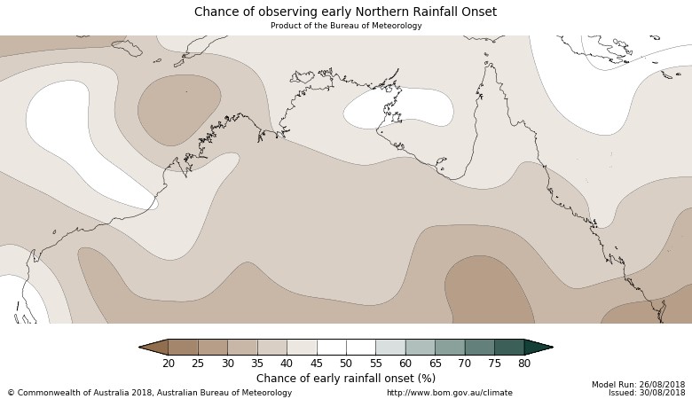
Figure 3 (above): When will it rain? There is a 35 – 45% chance of having an early wet season break across the Barkly Tableland. Source: Bureau of Meteorology
Figure 4 shows the past ‘skill’, or reliability, of the model based on actual historical observations. For most of the Barkly there is about a 55-65% chance that the forecast for the start of the wet season is correct. So that’s a bit better than 50/50.
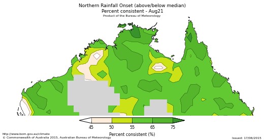
Figure 4 (above). How reliable is this forecast? The past ‘skill’ is moderate for the Barkly Tableland. Source: Bureau of Meteorology
“Why is it going to be late?”
Perhaps you’ve heard of El Niño? Well the forecasters are still predicting that an El Niño event is likely to form in 2018. Historically, El Niño years tend to result in drier conditions than normal, including a later wet onset, meaning we are less likely to get early storms across the Barkly. The good news is that once the monsoon begins, it largely overrides the effects of El Niño in northern Australia. Throughout this project I’m hoping you will find out more about these climate drivers and how they affect the Barkly. It can really help when trying to work out what a forecast means!!
“What is the wet season going to be like?”
You can have a look at the forecast for December to February on the BoM website. Search for climate outlooks, click on the top link and you should see the page shown in Figure 5. The forecast shows that it is likely that conditions will be drier than normal.
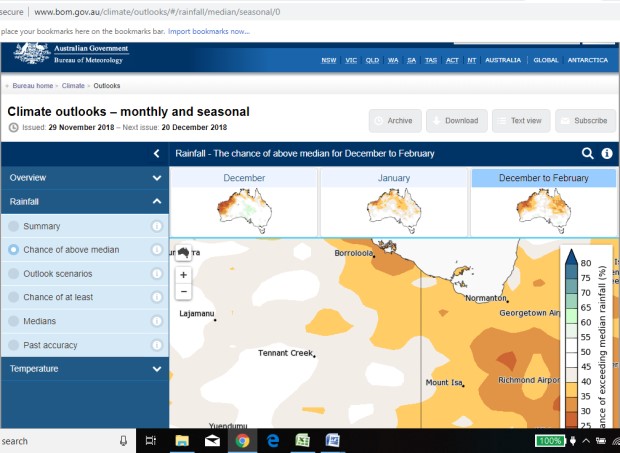
Figure 5. What are the chances of getting above average rainfall between December and February? (There is only a 35-45% chance of getting more than the long term median rainfall) Source: Bureau of Meteorology
“What is normal anyway?”
Apps such as CliMate (you can download it for free) use long term actual data for your property and you can ask quite specific questions e.g. how often do we receive over 200mm between December to February. Rainman is another very useful program I can help you access as well.
“But what about these early storms?”
The official start to the monsoon happens when the Intertropical Convergence Zone (ITCZ) shifts south creating the monsoon trough near northern Australia. This shift in the ITCZ causes the trade winds to shift from easterlies to westerlies. Early rainfall events can be distinguished from monsoon events because they do not rely on a shift of the trade winds/ITCZ. These early storms just happen randomly due to convection (ie the build-up of heat and moisture due to the difference in temperature between the land and the oceans). It is very difficult to forecast these early storms. Rain is rain though and that’s good!
Two things for your action
A half day workshop to understand climate drivers and forecasts.
When I started this project I had heard the terms ENSO, El Niño and the MJO but I didn’t really know much about them. Some very enthusiastic climate experts from BoM and the University gave us a really great introduction to the climate drivers that affect northern Australia and how they develop and use forecasts. We gained a greater understanding of all those terms and several more as well! We are looking at hosting such a workshop on the Barkly in early 2019 with experienced climate extension officers from Queensland. If you think it sounds like a good idea or perhaps you would even like to host such an event, send me an email or a phone call.
Seasonal forecasts specific to the Barkly.
As of early December, we will have northern Australia and Barkly specific seasonal forecasts available. If you would like these emailed to you then please get in touch.
Contact details
Alison Kain, Climate Mate for the Barkly Tableland
Facebook: Climate Mate for the Barkly Tableland
Ph: 0409 281 649 Email: alison.kain@usq.edu.au
Please note, the Climate Mate for East Kimberley and Victoria River District is Anne Marie Huey, who can be reached via annemarie.huey@usq.edu.auor by telephone on 08 9191 7069.
Give feedback about this page.
Share this page:
URL copied!