

Rangeland monitoring update
Gary Bastin, Manager - Rangeland Monitoring, Department of Land Resource Management
The Rangeland Monitoring Branch within the Department of Land Resource Management has responsibility for assessing, monitoring and reporting on land condition across the NT pastoral estate. There are four field teams of two people located across the NT; two teams in Alice Springs, one in Katherine and one in the department’s Palmerston office. On-ground assessments are complemented by remotely sensed analysis of the dynamics of vegetation cover with two scientific staff delivering this component.
The two Alice Springs field teams will visit 22 pastoral leases this year—four in the Southern Alice Springs Pastoral District, 13 in the Northern Alice Springs Pastoral District, two in the Plenty District and three in the southern part of the Tennant Creek Pastoral District. As at mid-August, 17 stations had been assessed.
Integrated monitoring program
The former Tier 1 monitoring program was upgraded in 2013 to provide more objective, landscape-scale reporting of changes in land condition across the pastoral estate. It comprises a network of ground-based sites, incorporating the existing Tier 1 sites where suitable, with newly established ground sites to validate and inform satellite data and products.
New sites are established, where required, adjacent to Tier 1 sites to maintain consistency in the photographic and data records. Where Tier 1 sites are not appropriate for inclusion in the integrated monitoring program, sites continue to be photographed to expand the Tier 1 photo archive.
The integrated monitoring program, like the previous Tier 1 system, is heavily reliant upon the knowledge and experience of land managers to fully explain observed changes and gain adequate understanding of landscape dynamics. The measured field data are also used to better calibrate nationally-based products derived from Landsat data to the particular requirements of the Northern Territory.
On-ground activity
During each station visit, monitoring staff:
1. Update infrastructure mapping based on discussions with the les see / manager and obvious changes noted while travelling around the station.
2. Relocate, photograph and assess existing Tier 1 sites. The assessment includes estimated level of bare ground, pasture species composition based on ground cover, evidence of woody thickening or erosion, and assigning a land condition class based on regional Grazing Land Management guides or other available published material.
3. Establish new measured sites on, or adjacent to, Tier 1 sites as required. Data collected at measured sites includes:
- ground cover by broad functional group (see photo). Categories include bare soil, cryptogam, litter, annual and perennial grasses, and annual and perennial forbs. The contribution of dominant species in each group to vegetated ground cover is also estimated
- the cover of trees and shrubs. Woody basal area is also measured where trees and shrubs are a significant component of the vegetation
- estimated density of juvenile trees and shrubs where recruitment may lead to woody thickening
- assessment of past or continuing erosion by type (scalding, wind sheeting, water sheeting, gullying) and severity (natural, slight, moderate, severe)
- recent fire history where appropriate—time since burnt and fire intensity
- additional contextual information such as the presence of any pest animals or weeds, forage abundance and level of grazing
- an assigned land condition class based on the above data and appropriate regional land condition guides. Also important here is that the quantitative data collected at future monitoring visits will allow us to reliably report change with regard to seasonal conditions experienced.
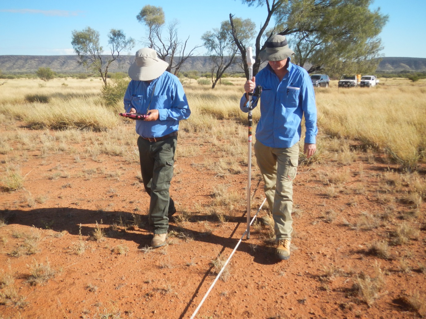
(Above) A laser pointer mounted on a pole is used to measure groundcover components at 300 points within one hectare at each measured site. Data are recorded using a tablet
4. Make visual assessments at other locations between fixed sites of the amount of bare soil (as the converse of ground cover), species composition of the pasture, tree-grass balance and any erosion. This information contributes to a more informed assessment of the condition of the more productive land types across the station.
Bare soil dynamics from satellite data
There is now national coverage of Landsat-derived fractional cover for all of Australia extending back to 1988. The Department of Land Resource Management has a formal agreement with the Queensland Government to adapt this product to best suit NT landscapes. Scientific staff from the Queensland Government were the primary developers of this Landsat product.
Each Landsat pixel is 30 square metres and can be ‘unmixed’ into fractional components of photosynthetically active (green) vegetation, non-photosynthetic (dry) vegetation and bare soil. Bare soil is the converse of green and dry vegetation. The two images on the following page show how the amount of bare soil has decreased over a 10-year period in a paddock on Old Man Plains Research Station. Such change is a product of seasonal variability (although both years had below-average rainfall), altered grazing management, spread of buffel grass and regeneration of witchetty bush (Acacia kempeana).
Imagery acquired in the latter part of each year is used for this type of analysis because it is important to maintain adequate ground cover at this time to minimise erosion risk from summer storms. The highly variable nature of rainfall in the southern NT also means that it is necessary to carry dry feed, and associated ground cover, into the hotter months in case summer rains fail.
Year-to-year change in the spatially-averaged level of bare soil on calcareous country within the paddock is shown in the graph at the end of this article. Such time traces show the highly dynamic nature of bare soil (conversely, vegetation cover) on sparsely timbered country in the arid zone. The amount of bare soil can decline to low levels following very good rainfall (2000-01 and 2010) and appreciably increase in ensuing dry years. Separate to this example, the amount of bare soil is also increased for several years where extensive wild fire follows such wetter periods.
The graph also illustrates how spatially-averaged bare soil on the calcareous plains in No 1 Paddock has been at a lower level in recent years of variable rainfall than it was under similar seasonal conditions 10 to 20 years ago.
Final word
Combining quantitative data collected at fixed monitoring sites, observations made at additional points of interest and spatially complete information about ground-cover dynamics provides a more informed assessment of land condition across each pastoral lease. These information sources are interpreted with respect to the knowledge and experience of land managers when compiling individual lease reports. The end-game for the department is to objectively report to the Pastoral Land Board and Minister on land condition across the NT pastoral estate at landscape and regional scales.
 (Above) Bare Soil – 2003 | 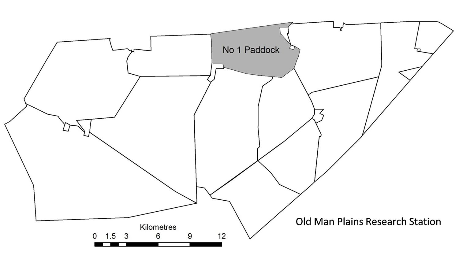 (Above) No 1 Paddock on Old Man Plains Research Station |
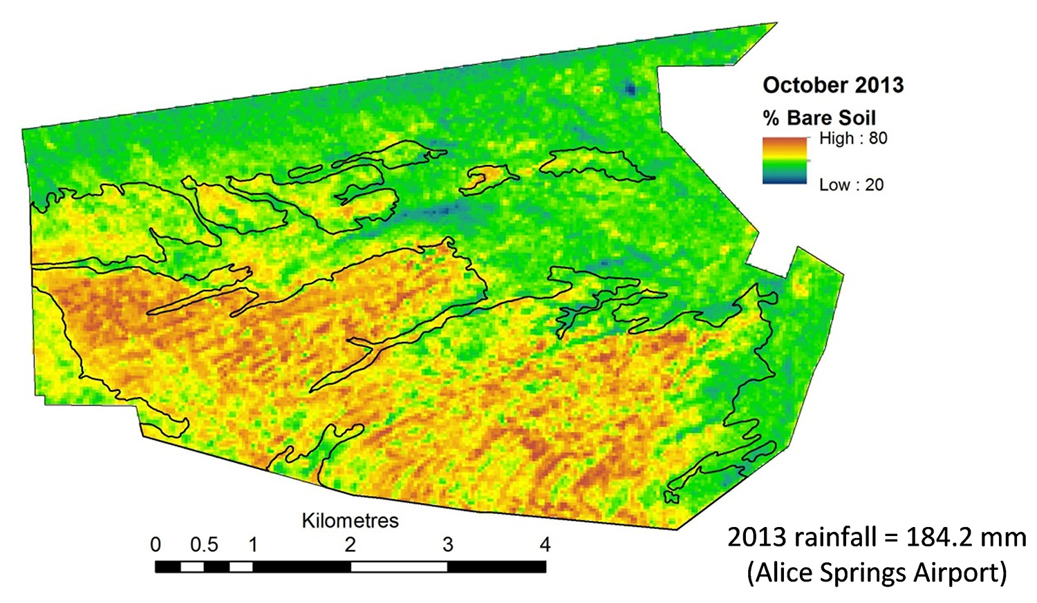 (Above) Bare soil - 2013 | 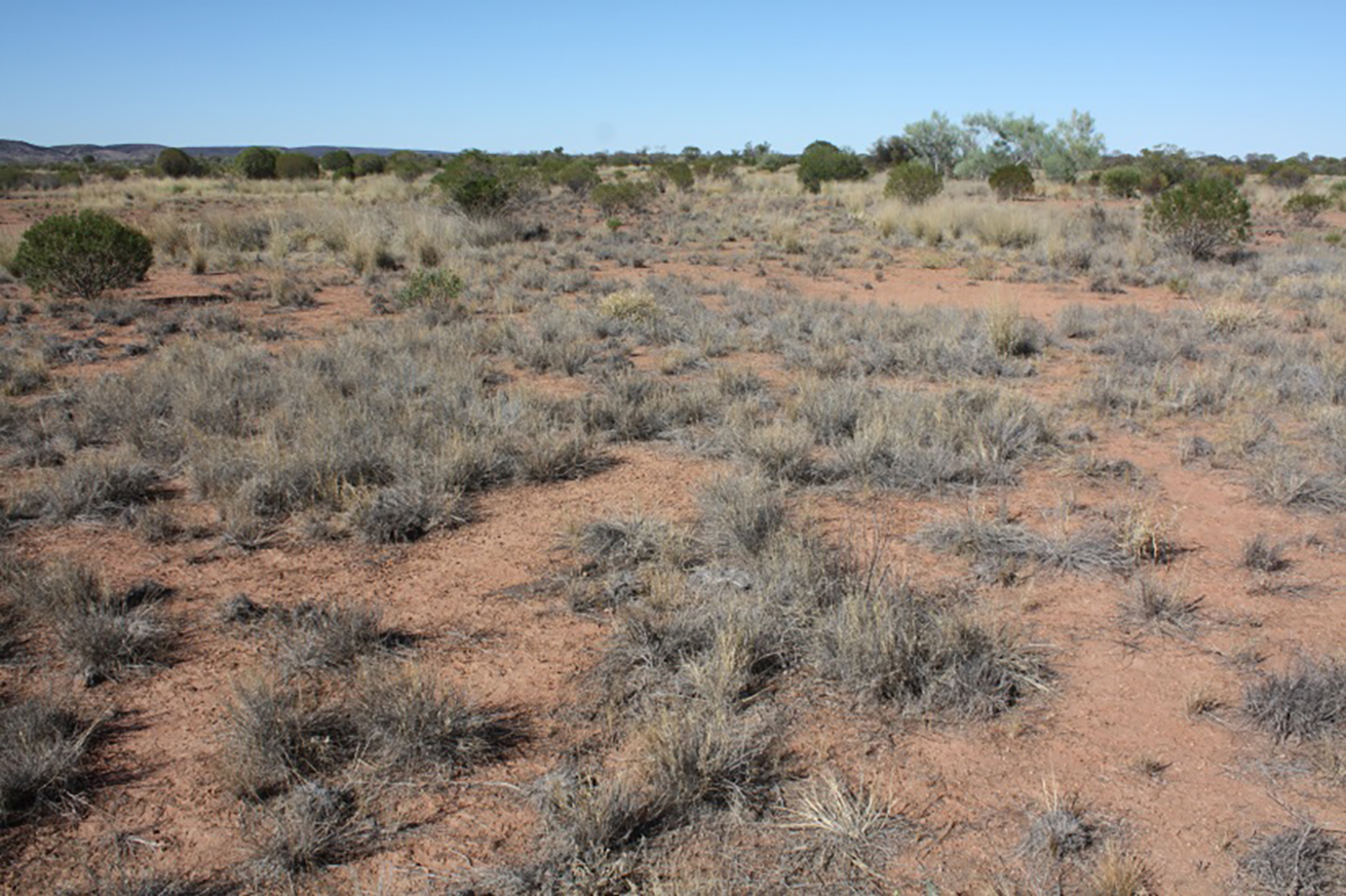 (Above) 2013 photo of monitoring site in calcareous country, No 1 Paddock (photo courtesy of Chris Materne, DPIR) |
Change in remotely-sensed bare soil in No 1 Paddock, Old Man Plains Research Station, between October 2003 and October 2013. The black line work delineates open calcareous plains. Both years had below-average rainfall.
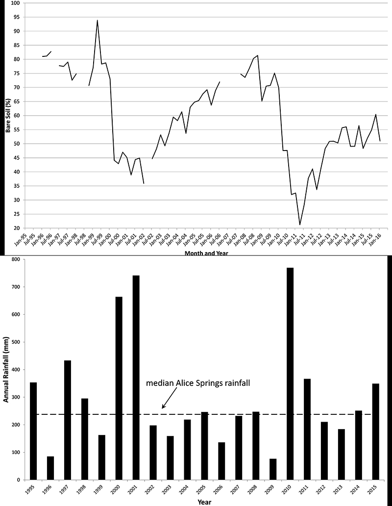
Annual rainfall (below) and time traces (above) of the average level of bare soil for the calcareous plains land type in No 1 Paddock, Old Man Plains Research Station (area = 15 sq km). Persistent cloud or issues with the thematic mapper sensor on the Landsat satellite account for missing data in the earlier years of the time trace. Rainfall is from the Alice Springs Airport. Median rainfall for Alice Springs is also shown.
Give feedback about this page.
Share this page:
URL copied!